A Complete Guide to Hiking from Eiði to Eiðiskollur
It was only our second day in the Faroe Islands, and the weather was already living up to its reputation—rainy, cloudy, and unpredictable. Still, after checking the FaroeIslandsLive webcams, we decided to head north to the village of Eiði. From here begins the hike to Eiðiskollur, a trail that promises sweeping coastal views and dramatic cliff scenery. Our start might not have been the smoothest, but this hike quickly turned into a valuable lesson about what hiking in the Faroe Islands is really like. Read on, and you’ll learn not only about the trail itself but also how to be better prepared for your own adventure.

- How to Get to Eiði
- Where to Park for Your Hike in Eiði
- How long is the hike to Eiðiskollur from Eiði Village
- Local Legends Around Eiðiskollur
- Our Waddle to Eiðiskollur
- Our Waddle of the Famous Eiðiskollur Hill
- Eiði Village
- The RAF Eiði Stone Shelter
- Why You Shouldn’t Hike in Foggy Weather in the Faroes
- 🐧 Penguin Pro Tips for Hiking in Fog
- The Radar Station on Eiðiskollur
- Facts About Eiðiskollur
- Best Time to Visit Eiðiskollur
- Is Eiðiskollur Hike Worth It
- Tips on What to Bring for the Eiðiskollur Hike
- Other Things to See Close By


How to Get to Eiði
Getting to Eiði is straightforward. The village is connected by public buses that run between nearby towns, making it possible to reach even without your own vehicle.
However, the schedules are limited and often don’t line up well with hiking plans. We had a rental car, and we strongly recommend having one—it’s practically a must in the Faroe Islands if you want the freedom to explore hikes like Eiðiskollur without worrying about timetables.
We came to Eiði from Tórshavn, the capital of the Faroe Islands. The drive covers about 60 kilometers and takes roughly one hour. The route is easy to follow, with scenic stretches along fjords and mountains, providing a preview of the landscapes to come before you even begin the hike.
Driving to Eiði: Tunnel or No Tunnel
There are two ways to reach Eiði from Tórshavn. The fastest and most convenient way is through the Eysturoyartunnilin, the undersea tunnel that cuts the journey to about 60 kilometers and reduces the driving time to just under an hour. The toll costs around 175 DKK one way.
If you’d rather skip the toll, you can take the scenic road around Sundini fjord. This longer route passes through Kollafjørður and across the bridge at Oyrarbakki before continuing toward Eiði. The drive stretches to approximately 75 kilometers and takes roughly 1 hour, but rewards you with beautiful fjord views along the way. We wanted to save on the toll, so we decided to take the scenic route, which turned out to be really beautiful.
Where to Park for Your Hike in Eiði
You have several options for parking.
- First, there’s a large parking lot right next to the public restrooms on the edge of the village, basically before you enter the center. We stopped there on our way in, and it’s an ideal place to leave your car before starting the trail. From this spot, it’s only a short walk into the village and toward the hiking path, and there is a nice public restroom you can use before your hike. Parking here is free, but it’s still quite far from the trail.


- Second, where we also parked our car, it was at the beginning of the trail. After using the restroom, we arrived in the village and parked in the small parking lot located within the village. Cons: It is smaller, with limited spaces, and there is no public bathroom. Pros: It’s close to the start of the trail.
Eiði Hike: Cost Breakdown (Per Person)
One of the best things about the Eiði to Eiðiskollur hike is that it’s completely free—there are no trail fees or entry charges. The only potential cost is the cost of getting there. If you use the Eysturoy undersea tunnel, you’ll need to pay the toll (about 175 DKK one way). If you choose the longer scenic road around Sundini fjord, you can skip the toll entirely. Apart from car rental and fuel, this hike incurs no additional expenses, making it a budget-friendly way to enjoy the dramatic Faroese coastline.
How long is the hike to Eiðiskollur from Eiði Village
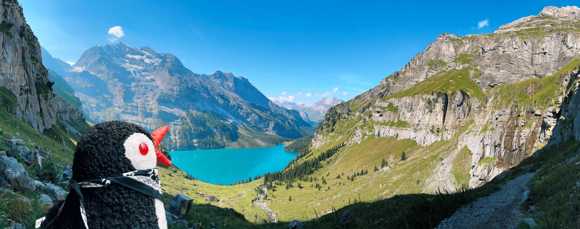
The hike from Eiði village to Eiðiskollur took us about 2 hours and 15 minutes in total, including plenty of photo stops and a short break at the top to enjoy the views. The trail covers roughly 4.75 kilometers one way, with an elevation gain of about 350 meters. The path is steadily uphill but manageable, rewarding you with sweeping coastal views when you go up and dramatic cliffs once you reach the summit, and weather permits.
Local Legends Around Eiðiskollur
One of the most enduring tales tied to Eiðiskollur involves the striking sea stacks just offshore, Risin (The Giant) and Kellingin (The Witch). According to Faroese legend, giants from Iceland were envious of the Faroe Islands and attempted to drag them back to Iceland. The Witch climbed Eiðiskollur and tied a rope around the island, but as she began to pull, the cliff cracked—a fissure said to remain visible to this day. Before they could complete their task, dawn broke, and the sun turned the pair into stone. The sea stacks that stand today are believed to be the petrified remains of their former selves, forever gazing longingly across the water toward Iceland.
Our Waddle to Eiðiskollur
- Waddle duration: 2 hours 15 minutes round trip (including photo stops) 😅
- Starting Point: Village of Eiði, Eysturoy Island
- Distance: 4.75 km (3 miles) round trip
- Elevation Gain: ~350 m (1,150 ft) steadily uphill
- Difficulty: Moderate; constant ascent with uneven grassy and rocky sections
- Route: Eiði village – uphill past open fields – ridge path – Eiðiskollur cliff viewpoint overlooking Risin & Kellingin sea stacks
- Trail Fee: None (free hike; only costs are fuel or toll if using the Eysturoy Tunnel)
- Map: link
- Public Transport: Limited buses reach Eiði, but schedules are sparse; a rental car is strongly recommended
- Things to see: Views of Risin and Kellingin (the Giant and the Witch sea stacks), sweeping panoramas of the northern Faroes, Eiði village from above, and dramatic cliff edges of Eiðiskollur
Our Waddle of the Famous Eiðiskollur Hill
The day started just as we had feared in the Faroe Islands, with cloudy skies and steady rain. Still, after checking the live webcams, we decided to head north toward the village of Eiði. When we arrived, the rain hadn’t let up, so we parked in the small lot by the public restrooms, grabbed a quick snack, and waited it out. Looking back, this damp and hesitant start should have been a clear forewarning of the hike ahead.


Eiði Village
Before (or after) the hike, if the weather permits, it’s worth spending a little time in Eiði, one of the northernmost villages on Eysturoy. With around 650 residents, it’s a peaceful settlement framed by mountains, the sea, and sweeping views of the iconic sea stacks Risin and Kellingin. Although small, Eiði has played a significant role in Faroese history and daily life.
Interesting fact: Eiði is home to one of the largest football fields in the Faroe Islands, dramatically perched right next to the ocean. It has become a favorite photo spot for many.
Quick Facts about Eiði Village
-
- Location: Northern Eysturoy, overlooking Risin and Kellingin
- Population: ~650 people
- Famous For: Ocean-side football field, considered one of the most scenic pitches in the world
- History: The village has roots dating back to Viking times, with archaeological remains found in the area
- Surroundings: Rolling hills, open grazing lands, and views of the Eiðiskollur cliff
- Nearby: Gjógv (a picturesque village with a natural harbor) and Funningur (linked to Faroese Viking settlements)


After about twenty minutes, the rain finally eased, and we took it as our chance to start the hike. We locked the car and headed straight up the hill. The trail began pleasantly enough—still damp from the earlier showers, but not yet overly muddy. Step by step, we waddled our way up, and almost immediately, after just a few meters, we were greeted with breathtaking views that made us forget the gray skies behind us.
For the first time, we also noticed the trail markings, which consisted of nothing more than piles of rocks, but were essential for finding the route. This would prove to be more important later, as many maps don’t clearly show the Eiðiskollur trail. As we climbed higher and higher, the slope grew noticeably steeper and the wind began to pick up. Nearing the top, we paused for a short break, catching our breath while watching the fog slowly roll in, hinting that the weather was about to turn again.


With the fog rolling in, we finally understood why there are so many warnings about hiking in the Faroe Islands. The visibility dropped to almost zero, and suddenly every direction looked the same. As a group of four, we decided to stick very close together so no one would get separated. The challenge was that there wasn’t a clear trail to follow, only the occasional cairn if you were lucky enough to spot it through the fog. At one point, we wandered slightly off course and found ourselves trudging through soggier ground than expected. Eventually, we managed to reconnect with the route, right at the base of a steep uphill section that tested both our legs and our patience.


Just as we were starting to wonder if we had gone completely off track, we heard voices coming from above. That little sound of company was reassuring—we weren’t alone up here after all. As we waddled up the steep incline, we met two girls making their way back down. They turned out to be locals and confirmed what we already suspected: the summit was completely wrapped in fog. Still, they encouraged us not to give up, telling us that if we waited a little, the mist would likely clear for a few minutes and reward us with the views. Their words gave us the push we needed, so we continued our uphill climb, even as the fog thickened and the weather turned increasingly grim.
The RAF Eiði Stone Shelter
On our way up, we reached our first stop: the RAF Eiði stone shelter. This small, sturdy structure was built during World War II, when the British established a radar station on Eiðiskollur to monitor the North Atlantic. The shelter is one of the few remnants from that time and still stands solidly against the elements. For hikers today, it offers a safe place to duck into if the weather turns rough—a real lifesaver on a rainy or windy day. When we visited, it was mainly foggy rather than rainy, so we didn’t need to hide inside for long, but it was fascinating to think about its wartime history while catching our breath on the climb.


We continued our climb toward the summit, but the fog only grew thicker with every step. Soon, visibility dropped so low that we could barely see a few meters ahead. What made it even trickier was that much of the path skirted the edge of the cliff, forcing us to move slowly and with extreme caution. Each step felt uncertain, and it became clear why people warn against hiking in such conditions.
Why You Shouldn’t Hike in Foggy Weather in the Faroes
Fog in the Faroe Islands can roll in within minutes, reducing visibility to almost nothing. Trails here are often unmarked, the terrain is steep, and cliffs drop suddenly into the ocean. Hiking in fog not only robs you of the stunning views but can also be genuinely dangerous if you lose your bearings near the edges.
🐧 Penguin Pro Tips for Hiking in Fog
- Stick together as a group and never hike alone.
- Follow cairns (rock piles) carefully; they’re often the only markers of the trail.
- Use a GPS app or offline maps, as most trails are not marked on standard maps.
- Move slowly near cliffs; it’s better to be safe than sorry.
- Carry extra warm layers; the damp fog can chill you quickly.
- Wait it out if possible. Fog often clears in short bursts, revealing the views.
- Always share your route with someone before heading out.
The Radar Station on Eiðiskollur
After passing the first RAF Eiði shelter, we continued uphill and eventually reached the site of another radar station from World War II. During the British occupation of the Faroe Islands, the Royal Air Force established several outposts, including this one, to monitor German naval and air activity in the North Atlantic. At Eiðiskollur, they constructed stone shelters, radar equipment, and observation points, remnants of which can still be found scattered across the hill.


When we arrived at the summit, the visibility was absolutely zero. The famous views were completely hidden behind a thick wall of fog. Instead of pushing further along the edge, we ducked into the second stone shelter, pulled out our thermos, and enjoyed a cup of coffee with a few snacks. Even though we couldn’t see anything, the moment had its own charm, the silence was complete, the fog made everything feel otherworldly, and the place carried a strange sense of serenity.


We ended up spending around twenty minutes at the shelter, hoping the fog would finally lift. For a brief, almost magical moment, maybe ten seconds, the clouds opened and we caught a glimpse of the views we had climbed for. But just as quickly, the fog swallowed everything again. Soon after, we heard the voices of another group of tourists approaching through the mist. Realizing the weather wasn’t going to improve, we decided it was time to make our way back down.
On the way down, we discovered that the foggy climb had only been the beginning. At first, a drizzle accompanied us, nothing too dramatic. But as we descended toward the first stone shelter, the rain intensified, forcing us to take cover for a few minutes. We quickly layered on whatever waterproof gear we had left, pulled gloves over our cold hands, and covered our backpacks as best we could. The plan was to wait it out, but instead of easing, the rain only grew heavier, drumming against the stones and reminding us once again how fast the weather in the Faroes can turn.
Eventually, we realized the rain wasn’t going to let up, so we decided to descend despite the weather. Once we started, we knew we couldn’t afford to stop again. It was still foggy, now pouring rain, and the wind had picked up, making everything more challenging. We stuck tightly together so no one would drift off in the mist. The first stretch of the downhill went smoothly enough, with a faint trail to follow. But further down, things got confusing; the path faded, and we lost our way in the fog. We tried using GPS, but it struggled even in the thick clouds. After some careful navigating, we finally picked up the route again and made it safely back to the village.
By the time we arrived, we were completely drenched. The hike taught us an important lesson: waterproof clothing is only waterproof to a point, certainly not to the extremes the Faroese weather can throw at you.


Facts About Eiðiskollur
- Location: Northern tip of Eysturoy Island, near the village of Eiði
- Elevation: Around 352 meters (1,155 ft) above sea level
- Famous View: Overlooks the legendary sea stacks Risin and Kellingin (the Giant and the Witch)
- Landscape: Open grassy slopes used for sheep grazing, with steep cliff edges
- History: Site of RAF radar stations during World War II, built by the British
- Weather: Known for sudden fog and strong winds, making visibility unpredictable
- Trail: Unmarked path; hikers follow cairns (rock piles) to navigate
- Cost: Free to hike, no trail fees (only possible tunnel tolls to reach Eiði)
- Nearby: The village of Eiði, Gjógv, and the Atlantic bridge at Oyrarbakki
Best Time to Visit Eiðiskollur
When it comes to seasons, the best time to hike Eiðiskollur is late spring to early autumn (May–September). During these months, the weather is at its mildest, the days are longer, and the chances of catching clear views of Risin and Kellingin are higher. Winter hikes are possible but not recommended unless you’re very experienced, as the trail can be slippery, daylight is limited, and sudden storms are common.
As for the time of day, it’s best to start your hike in the morning or early afternoon. Mornings often offer calmer winds and better visibility, though, as we learned from our hike, this’s not always the case. An earlier start ensures you have enough daylight in case the hike takes longer than expected. Sunset can be beautiful from the summit, but you risk descending in fog or darkness, which can be dangerous given the cliffs and unmarked trails.


Is Eiðiskollur Hike Worth It
Yes, absolutely. Even though we didn’t get the clear views we were hoping for at the summit, the hike itself was an adventure we wouldn’t trade for anything. From the challenging climb and sudden weather changes to the eerie silence of the fog and the history hidden in the old RAF shelters, it was an experience full of lessons and memories. The Faroe Islands are unpredictable, but that’s part of their magic. And if we had the chance, we’d waddle up Eiðiskollur again in a heartbeat, this time hoping the cliffs and sea stacks would finally reveal themselves.
Tips on What to Bring for the Eiðiskollur Hike
- Waterproof jacket and pants. The weather changes quickly, and rain is almost guaranteed.
- Sturdy hiking boots with a good grip for wet grass and rocky ground
- Gloves and a hat, it can get cold and windy, even in summer
- Backpack cover or dry bags to protect your gear from rain
- A thermos with a hot drink and snacks, perfect for breaks at the shelters
- Offline map or GPS app, trails are unmarked, and fog makes navigation tricky.
- Fully charged phone and power bank, in case you need extra battery for navigation or emergencies.
- Extra warm layers are recommended, as temperatures can drop suddenly at the top.
- Water bottle, there are no sources along the trail.
Other Things to See Close By
- Risin and Kellingin sea stacks. Best viewed from the coast near Eiði or from Tjørnuvík beach.
- Eiði football field. One of the world’s most scenic pitches, right by the ocean
- Gjógv. A charming village with a natural gorge harbor, about 20 minutes from Eiði.
- Funningur. One of the oldest Faroese settlements, linked to Viking history
- Oyrarbakki Bridge. “The only bridge over the Atlantic,” connecting Eysturoy and Streymoy.
Looking back, our hike to Eiðiskollur was far from easy. Between the relentless fog, heavy rain, and tricky navigation, it tested both our gear and our patience. Yet, despite the lack of sweeping summit views, the experience was unforgettable. We learned firsthand how unpredictable the Faroese weather can be, why preparation matters, and how even the toughest moments become part of the adventure. In the end, the waddle was worth it, not for the pictures we couldn’t take, but for the story we’ll never forget.
Pack Your Bags and Explore the Faroe Islands!

This post contains affiliate links. If you click and buy, I might earn a tiny commission, enough to help a penguin keep up its globe-trotting lifestyle. No extra cost to you, just more fish for me. Thank you for supporting the adventure!