Hike to Bøsdalafossur Waterfall in the Faroe Islands
When you start researching the Faroe Islands, this is probably the first picture you see on Google: Sørvágsvatn seemingly floating above the ocean, ending in a dramatic waterfall. We saw it too, and from that moment, there was no question. Bøsdalafossur had to be part of our journey. So we laced up our boots, packed our camera, and set out to see if reality could live up to that first, almost unreal image. Spoiler: it did. And then some. Read on to learn everything you need to know about the waddle to Bøsdalafossur waterfall.

- How to get to Bøsdalafossur Waterfall
- Reaching Bøsdalafossur Waterfall from Tórshavn
- Where to park for your hike to Bøsdalafossur Waterfall
- Bøsdalafossur Waterfall Hike – Cost Breakdown (Per Person)
- How long is the hike to Bøsdalafossur Waterfall
- How to Pay for the Bøsdalafossur Waterfall Hike
- Local Legends Around Bøsdalafossur Waterfall
- Waddling the Famous Lake Sørvágsvatn Trail
- The Slave Cliff: Trælanípa
- Sørvágsvatn: The Lake Above the Ocean
- Reaching Bøsdalafossur: The Highlight of Our Waddle
- Best Time of Day to Visit Bøsdalafossur Waterfall
- Is Bøsdalafossur Waterfall worth visiting?
- Tips on What to Bring for Bøsdalafossur Waterfall Hike
- Other Things to See Close By


How to get to Bøsdalafossur Waterfall
Bøsdalafossur sits on Vágar Island in the Faroe Islands, flowing from Sørvágsvatn (Leitisvatn) into the North Atlantic. The waddle begins near the village of Miðvágur, just a short drive from Vágar Airport.
From the airport, it’s only a 10-minute drive to the trailhead parking area. You follow signs toward Miðvágur and then to the Sørvágsvatn/Trælanípa hiking area. Note, all visitors must go through the main gate and check in at the landowners’ reception at the beginning of the trail.
Reaching Bøsdalafossur Waterfall from Tórshavn
Getting to Bøsdalafossur Waterfall from the capital is a straightforward and scenic drive that takes you through the Vágatunnilin (Vágar subsea tunnel), which links Streymoy to Vágar Island. The tunnel toll is 100 DKK round trip per car, usually billed automatically by rental companies or payable online within six days at tunnil.fo. From Tórshavn, the journey to the trailhead near Miðvágur took us around 50 minutes, with well-paved roads and stunning views along the way. Once there, we started the easy-to-moderate walk toward the “lake above the ocean” viewpoint before continuing to the dramatic point where Lake Sørvágsvatn spills into the Atlantic as Bøsdalafossur.
Where to park for your hike to Bøsdalafossur Waterfall
There is a designated paid parking lot near the start of the trail, which is pretty spacious and convenient for most visitors. Right next to it, a small booth collects the hiking fee as the path runs across private land and the payment supports its upkeep. One thing to keep in mind: after heavy rain, the parking area can get muddy, so drive in carefully and wear suitable shoes before stepping out.


Bøsdalafossur Waterfall Hike – Cost Breakdown (Per Person)
- Vágatunnilin (Vágar subsea tunnel) – 100 DKK round trip per car
- If two people share, the cost per person is 50 DKK
- Parking & Hiking Fee – 200 DKK per adult (includes trail access and parking)
- Total Cost Per Person – 250 DKK (~34 EUR)
- Notes:
- No ferry needed
- Optional to pre-book entry online at trælanípa.fo
- Fee also covers access to the Trælanípa “Lake Above the Ocean” viewpoint
If you hike on your own, the fee is 200 DKK per adult (ages 16 and up). Children aged 0–15 hike for free. You pay this at the turf-roofed hut near the trailhead at the car park. The fee covers access to the trail, use of the car park, and restroom facilities.
-
- Guided hikes cost 600 DKK per person, inclusive of trail access, guide services, refreshments, and an info folder. Booking (minimum five people) is required.
Parking for the Bøsdalafossur Waterfall and Trælanípa hike is included in the 200 DKK access fee you pay at the trailhead. There is no separate parking charge—once you pay for entry, you can leave your car in the designated lot near the start of the trail for the duration of your visit. The parking area is a short walk from the ticket booth and trail entrance, with space for standard cars and small campervans.
For hiking fees of other hikes, the Faroe Islands have a great website which gives you all prices and other usefulinformation. Check out hiking.fo for more.


How long is the hike to Bøsdalafossur Waterfall
The hike to Bøsdalafossur is about 3 km one way (roughly 6 km round trip) on a mostly flat, grassy path. The first part of the waddle hugs the shoreline of Sørvágsvatn, offering early glimpses of the lake’s famed “floating” illusion. Continue following the path until you reach the cliff area near Trælanípa, then turn toward the sound of rushing water. Bøsdalafossur comes into view as the lake spills directly into the ocean.
If you’re short on time, you can head straight for the waterfall and skip climbing Trælanípa, but many visitors combine both in one loop since the viewpoints are close together.
The total hike takes 2–3 hours, depending on how long you spend soaking in the views (and trust me, it’s easy to linger).


How to Pay for the Bøsdalafossur Waterfall Hike
- Credit or debit card. Visa and Mastercard are accepted at the small turf-roofed ticket booth near the parking lot.
- Cash. Danish krone (DKK) is accepted; some attendants also take euros, but change is given in DKK.
- MobilePay. Common in the Faroe Islands, applicable if you have a Faroese or Danish account.
🐧 Pro Penguin Tip
It’s best to carry cash since weather, staffing, or mobile coverage can sometimes affect cash or app payments.
Local Legends Around Bøsdalafossur Waterfall
There is no visit to a new country where we would not ask locals about the local legends. And the waterfall has several.
Huldufólk (Hidden People). Around Sørvágsvatn, locals share stories of Huldufólk—mystical beings that live in mounds and rocks. One tale recounts a Huldu-woman inviting a priest into her hidden realm. When he left, he sealed the mound to keep its inhabitants hidden, but villagers still report hearing mysterious wailing from within.
Nykur (Nix): The Enchanting Lake Horse. Folk tales say a shape-shifting water spirit called the Nykur lurks in the lake. It often appears as a beautiful horse, luring unsuspecting children onto its back before dragging them beneath the waves. In one story, a young child stuck on its back called out its own nickname (“Nika”), confusing the Nykur, who “lost its power and disappeared,” saving the child.
Trælanípa: The Dark Echoes of the Slave Cliff. Overlooking Bøsdalafossur is the vertical cliff called Trælanípa, or “Slave Cliff,” which carries a grim Viking-age superstition. It’s said that enslaved people who disobeyed or were deemed unfit were thrown over the cliff into the ocean below, adding a deeply human and haunting edge to this stunning landscape.
Our Waddle to Bøsdalafossur Waterfall
- Waddle duration: 2 hours 48 minutes round trip (including photo stops) 😅
- Starting Point: Trælanípa/Bøsdalafossur trailhead near Miðvágur, Vágar Island
- Distance: 7.74 km (4.8 miles) one way
- Elevation Gain: Minimal – gentle inclines across grassland
- Difficulty: Easy to moderate; well-marked path but can be muddy and windy near cliffs
- Route: Trailhead – Trælanípa “Lake Above the Ocean” viewpoint – along Sørvágsvatn lake shore – Bøsdalafossur Waterfall plunging into the Atlantic
- Trail Fee: DKK 200 per adult / DKK 50 per child (includes trail access and parking)
- Map: link
- Public Transport: Limited bus service from Tórshavn to Miðvágur; rental car recommended
- Things to see: Cliff-top view of Sørvágsvatn (“lake above the ocean”), Bøsdalafossur waterfall, dramatic sea cliffs, views toward the islets of Tindhólmur and Drangarnir
Waddling the Famous Lake Sørvágsvatn Trail
We pull into the official parking lot, the cliffs already teasing us from a distance. The air smells of salt and damp grass. After parking the car, we waddle over to the small turf-roofed ticket office, but not before making a quick stop at the onsite bathroom—clean, stocked, and much appreciated before setting off. Kudos to the team for keeping it in such good condition. Once ready, we proceed through the booth where every hiker pays an entrance fee of 200 DKK per person, which also covers parking.Inside, you can also pick up small snacks and local souvenirs—a nice touch if you want a treat for the hike or a memento to take home. With tickets in hand, we shoulder our bags and step onto the well-marked path toward the lake. Each step brings the shimmer of Sørvágsvatn closer, and with it, the promise of that first glimpse of Bøsdalafossur tumbling into the Atlantic.


After all the formalities, we finally head toward the waterfall. Although Bøsdalafossur is the clear highlight, the surrounding area refuses to play second fiddle. The trail hugs the shoreline of Sørvágsvatn, the so-called “floating lake,” with views that shift and surprise at every bend. To one side, grassy slopes roll gently toward the water; to the other, cliffs rise in rugged steps, occasionally splitting to reveal glimpses of the Atlantic. Bird calls carry on the wind, and in the distance, the jagged outline of Trælanípa beckons. Along the way, you might spot the solitary sea stack Geituskoradrangur jutting defiantly from the ocean, or WWII stone remnants quietly blending into the landscape. It’s a place where every pause rewards you with another frame-worthy view.
Not far from the ticket office, we were greeted by the true locals of the trail—cows grazing lazily in the fields and sheep dotting the hillsides. They wandered freely across the path, unfazed by passing hikers, adding a touch of charm to the start of the walk. Sharing the trail with them felt like an authentic Faroese welcome and a reminder that these landscapes are as much farmland as they are hiking routes.


The terrain from the parking lot to Bøsdalafossur is gentle and open, making it one of the more approachable hikes in the Faroe Islands. The path weaves over firm grassy ground, with occasional rocky patches and short stretches that can turn muddy after rain. There’s little elevation gain, so your legs can focus on soaking up the scenery rather than conquering climbs. The trail follows the contour of Sørvágsvatn, keeping the lake in view for most of the waddle, and the footing stays steady enough for a relaxed pace. Near the waterfall, the ground becomes slightly more uneven, with basalt rock edges and areas where you’ll want to watch your step, especially if it’s wet or windy.


The Slave Cliff: Trælanípa
This spot truly caught us by surprise. We waddled along the trail, focused on the lake, and then suddenly the ground gave way to a sheer drop—Trælanípa, better known as the Slave Cliff. Rising about 142 meters above the Atlantic, this cliff takes its name from old stories that slaves were once pushed over the edge here. Standing at the top, with the wind whipping across the plateau, you feel both the danger and the raw beauty of the place. The views are breathtaking, but the edges demand caution—on windy days, especially, it’s wise to stay a safe distance back while still taking in the incredible panorama.


From the Slave Cliff, the trail continues along the ridgeline, offering some of the best views over Sørvágsvatn as it stretches toward the horizon. Walking here feels both exhilarating and humbling—the lake on one side, the vast Atlantic on the other. The wind often picks up along this exposed section, so keep a firm footing and stay mindful of the cliff edges. It’s a waddle worth taking slowly, letting each step reveal another perspective of the famous “lake above the ocean” illusion.


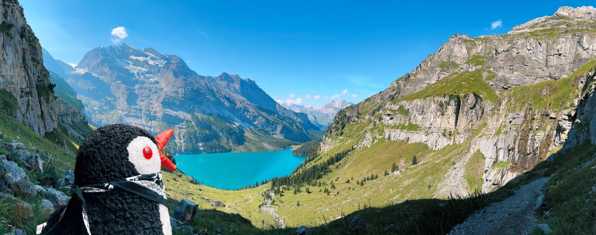
Sørvágsvatn: The Lake Above the Ocean
Sørvágsvatn, also known as Leitisvatn, is the largest lake in the Faroe Islands and the star of this hike. Stretching approximately six kilometers, it sits high on the cliffs of Vágar, creating the famous optical illusion that the water appears to hang directly above the Atlantic Ocean. From the trail, the lake stays in view almost the entire time, its surface shifting color with the changing skies. At the far end, the water meets the edge of the cliffs before plunging as Bøsdalafossur waterfall, a dramatic finale that makes this hike one of the most photographed experiences in the Faroe Islands.
Quick Facts About Sørvágsvatn:
- Length: approx. 6 km
- Width: up to 800 m
- Maximum depth: about 59 m
- Total area: 3.4 km², making it larger than all other Faroese lakes combined
- Outflow: Bøsdalafossur waterfall, dropping 30 m directly into the Atlantic

Reaching Bøsdalafossur: The Highlight of Our Waddle
The last part of the waddle feels like a slow reveal. The sound of rushing water grows louder, and soon the grassy path gives way to dark basalt, the Atlantic opening up ahead. Then it appears, Bøsdalafossur, plunging about 30 meters from Sørvágsvatn into the sea. You can stand right near the edge (with caution) and watch freshwater meet saltwater in a single, thundering drop.


The view stretches beyond the waterfall itself: to the left, the jagged profile of Trælanípa; straight ahead, the restless expanse of the North Atlantic; and on a clear day, the solitary spike of Geituskoradrangur sea stack in the distance. This spot isn’t just about the waterfall; it’s about seeing the lake, cliff, and ocean all in one sweeping panorama. The hike here takes roughly 45 minutes from the parking lot at a steady pace, but you’ll want to add at least another half-hour, probably more 😅, for taking photos, watching seabirds, and simply letting the drama of the landscape sink in.
Facts About Bøsdalafossur Waterfall
-
-
- Waterfall Height: ~ approx. 30 meters (98 feet) from Lake Sørvágsvatn into the North Atlantic.
- Source Lake (Sørvágsvatn / Leitisvatn): surface area is around 3.4 km² (1.3 sq mi), and average depth is about 27.5 meters (90 ft).
- Maximum Depth: Roughly 59 meters (194 ft). Wikipedia
- The lake sits 30–40 meters above sea level, walled by cliffs that create the famous optical illusion of a “floating lake.”
- Drainage Stream: The short, hidden outlet stream runs only a few hundred meters from the lake to the waterfall’s edge.
- Water flow depends heavily on recent rainfall. The Faroe Islands experience high precipitation, over 4,000 mm annually in some spots, so stream discharge fluctuates dramatically between heavy rains and drier periods.
-
Name Meaning. “Bøsdalafossur” translates from Faroese as “The Waterfall of Bøsdalur”, referring to the nearby valley (dalur) and its connection to the lake and surrounding landscape.
-
After soaking in the views from the cliffs, we waddled further down to the spot where the lake spills over into the sea as Bøsdalafossur. From here, you get another striking vantage point—the lake stretching calm and wide behind you, before suddenly narrowing and dropping in a mighty rush toward the Atlantic. Standing at the edge, you feel the contrast between the stillness of Sørvágsvatn and the roar of the waterfall below.


Eventually, we turned back toward the car, each step carrying a quiet reluctance to leave. There was a bittersweet pull in walking away, but the sight of cliffs dissolving into the ocean, the shimmer of the lake, and the sound of falling water are the kind of impressions that stay with you long after the Faroese winds fade.


Best Time of Day to Visit Bøsdalafossur Waterfall
Bøsdalafossur flows from Sørvágsvatn Lake directly into the Atlantic Ocean, and the best time of day to visit depends on whether you’re chasing light or atmosphere.
-
-
-
- Morning. Offers soft light over the lake and fewer people on the trail. The ocean side of the waterfall can be in partial shade, giving a more dramatic, moody look in photos.
- Midday. Brightest views of both the lake and the ocean, but also when the trail is busiest. Good for clear, high-contrast photography.
- Late Afternoon to Early Evening. The most striking time for photography is when the low sun warms the cliffs and makes the spray from the waterfall glow. If the weather is calm, this is also when reflections on Sørvágsvatn are clearest.
-
-
🐧 Pro Penguin Tip
For the perfect balance, aim for late afternoon on a clear or partly cloudy day. You’ll catch the golden light on the cliffs and have enough time to complete the hike back before sunset.
Is Bøsdalafossur Waterfall worth visiting?
Yeeeeeees!! Bøsdalafossur Waterfall is absolutely worth visiting. This is where Lake Sørvágsvatn plunges 30 meters into the North Atlantic, creating a rare meeting of calm freshwater and powerful ocean waves. The short, mostly flat waddle from Miðvágur delivers more than just the waterfall; you also get the famous “floating lake” illusion from the nearby Trælanípa cliffs, sweeping ocean views, and sights like the Geituskoradrangur sea stack. The trail is easy to follow, and the payoff is immense: a landscape that captures the raw, elemental spirit of the Faroe Islands in one place. It’s a spot that lingers in your mind long after you leave, and easily earns a place on any Faroe Islands itinerary.
Tips on What to Bring for Bøsdalafossur Waterfall Hike
-
-
-
- Waterproof jacket. Faroese weather changes fast, and wind-driven rain is common.
- Layers. A moisture-wicking base layer and a warm mid-layer keep you comfortable in shifting temperatures.
- Sturdy walking shoes or hiking boots. The trail can be muddy and slippery, especially after rain.
- Waterproof pants. Optional, but great if the forecast calls for heavy rain or strong wind.
- Hat and gloves. Even in summer, it can feel chilly near the cliffs.
- Daypack. To carry snacks, water, and any extra layers.
- Water bottle. There are no refill stations along the trail.
- Camera or smartphone. The views are some of the most photogenic in the Faroes.
- Binoculars. Ideal for spotting seabirds around the cliffs.
- Sunglasses. The glare off the lake and ocean can be strong on sunny days.
- Cash. For paying the entrance fee at the trailhead.
-
-
Other Things to See Close By
- Geituskoradrangur Sea Stack. A striking rock formation rising from the ocean, visible from the trail near Bøsdalafossur.
- Miðvágur Village. A charming village with local shops, cafés, and a peaceful lakeside atmosphere.
- Sandavágur Church. Known for its bright red roof and beautiful location overlooking the bay.
- Vágar Airport WWII Ruins. Remnants from the British occupation during World War II are just minutes from the trailhead.
- Gásadalur and Múlafossur Waterfall. One of the Faroe Islands’ most photographed spots is about a 20-minute drive away.
- Drangarnir Sea Stacks. Dramatic twin sea stacks, accessible via guided hikes or boat tours from nearby Sørvágur.
- Tindhólmur Islet. A distinctive, jagged islet best viewed from Sørvágur or during a boat trip.
- The Nix Statue. Located in Miðvágur near Sørvágsvatn’s shore, just a few minutes’ drive from the Bøsdalafossur trailhead.
- Trøllkonufingur Viewpoint (optional). About a 15–20 minute drive from Miðvágur toward Sandavágur, with a short hike for views of the “Troll Woman’s Finger” sea stack.
- Bøur. A small, picturesque village about 20 minutes’ drive from Miðvágur, with postcard views toward Tindhólmur and Drangarnir.
- Drangarnir. Dramatic sea stacks near Sørvágur; best reached via guided hike or boat tour from Sørvágur (10 minutes from Miðvágur).
- Múlafossur Waterfall. In Gásadalur village, about a 25-minute drive from Miðvágur, is known for its cliffside drop into the Atlantic.


The hike to Bøsdalafossur isn’t the longest or the toughest in the Faroe Islands, but it captures so much of what makes these islands unforgettable—raw cliffs, shifting skies, and landscapes that keep surprising you around every bend. From the optical illusion of Sørvágsvatn to the dramatic drop of the Slave Cliff, and finally the thunder of the waterfall itself, every stage of the trail feels rewarding. It’s a waddle that combines ease with drama, making it one of the best introductions to hiking in the Faroes. When we finally left, it wasn’t just photos we carried with us, but the sound of the falls and the memory of standing between lake and sea—a moment that lingers long after the trail ends.
Pack Your Bags and Explore the Faroe Islands!

This post contains affiliate links. If you click and buy, I might earn a tiny commission, enough to help a penguin keep up its globe-trotting lifestyle. No extra cost to you, just more fish for me. Thank you for supporting the adventure!
3 thoughts on “Bøsdalafossur Waterfall Hiking Guide: Where the Lake Meets the Sea”
Comments are closed.