Up by Car, Down on Foot: A Spontaneous Lake Hike Through Tauplitzalm
We try something different this time. Instead of the usual uphill waddle, our friends drove us up. No grand plan, just a hunch that starting at the top might offer something new. The car winds its way up the Tauplitz Alpine Road, each turn revealing more of the landscape we’re about to waddle. At that point, we didn’t know we’d end up waddling all the way down. But that’s the best part, Tauplitzalm invites improvisation.
At 1,650 meters, the plateau doesn’t make you work for the view. It gives it freely. One step out of the car, and it’s all there, vast skies, alpine lakes, ridgelines stretching toward the horizon. Read on to learn what to expect, how our adventure went, where to park, and more.


Tauplitzalm lies in the Styrian corner of the Salzkammergut, in the heart of the Ausseerland. It’s a high plateau carved out by glaciers and now dotted with lakes, wildflowers, and trails that disappear into the distance. Known for its accessibility and mountain atmosphere, it’s one of Austria’s best places to dip into alpine hiking without needing a summit bid.
The morning air feels crisp as we begin to explore the plateau, energy intact. No sore legs, no uphill slog. Just the excitement of being high in the mountains. And though we don’t know it yet, by day’s end, we’ll follow the trail down, trading altitude for perspective, one step at a time.
How to Get to Tauplitzalm
Reaching Tauplitzalm is relatively easy, as Austria has thought of everything. Below, we walk you through the main options so you can choose the route that suits your adventure, just as we did.
- By bus. Regional buses run from Tauplitz village and surrounding towns (like Bad Mitterndorf or Liezen) to the plateau. Check the summer timetable, and expect a short ride that leaves you right near the cable car and summit area.
- By cable car (if in operation). The famous four-seater chairlift is also a popular option for going up and down. It starts from Tauplitz station in the valley up to a mid‑plateau station. From there, it’s a scenic waddle or short ride to the higher alpine trails. It’s an effortless way to gain altitude and save your legs for exploring. Overall, it takes about 20 minutes. For more information, visit their official website.

- By car (like us). You can also drive the 10-kilometer-long Tauplitzalm Alpine Road from Bad Mitterndorf. It’s one of Austria’s most beautiful alpine drives, winding past sweeping views of the Grimming (2,351 m) to the south, the Dachstein range to the west, the Totes Gebirge to the north, and the Gesäuse mountains to the east. The toll for private vehicles is €16 (summer season)—more information is available on their website.
Where to Park and What to Expect at the Top
Once you reach the top of the Tauplitzalm Alpine Road, you’ll find a large, free parking area above 1,600 m just before the entrance to the main plateau trails. There’s no stress about finding a spot; this lot easily handles day-trippers, hikers, and even campervans in summer. It’s a convenient base to start your adventure, whether you’re heading out for a short loop or the full descent back to the valley.
Right next to the parking area, there’s a well-maintained public bathroom. It’s clean, stocked, and a welcome stop before you head into the mountains, especially if you’ve been on the road for a bit. From there, signs point clearly to various trailheads, alpine huts, and lake paths. Everything starts just a few steps from where you park.


Best Hikes Starting at Tauplitzalm Parking Area
Right from the large free car park on Tauplitzalm, you’ll find several well-marked trails that offer hiking options suitable for all levels, from gentle lakeside waddles to more challenging peak routes. Here are the most popular trails.
- 6‑Lakes Loop (6‑Seen‑Wanderung). The most famous one. A 13‑km circuit around all six of Tauplitzalm’s high‑alpine lakes: Tauplitzsee, Großsee, Märchensee, Steirersee, Schwarzensee, and Krallersee. Takes around 4–5 hours, with roughly 400 m of elevation gain and loss. Mostly easy terrain, mostly gravel and alpine paths.
- Steirersee–Schwarzensee Loop. Shorter variation (~3.5 hours) that circles around the two lakes, with an optional stop at Leistalm hut in summer.
- Lawinenstein or Almkogel Summit Trails. More strenuous routes starting from the car park leading to peaks like Lawinenstein (1½–3.5 h) via trails 271 or 274—steeper and recommended only uphill.
- Ödernalm & Bad Mitterndorf Descent. A longer trek descending all the way to lower Ödernalm or even Bad Mitterndorf—perfect for hikers who want a full day out.
- Gnanitzalm Route. A scenic path that passes Steirersee and Schwarzensee before reaching Gnanitzalm, ideal for a varied, moderate hike.
Penguin Trail Selection Tips
- Want a relaxed lakeside stroll? Choose the 6‑Lakes Loop—flat, clear paths, family‑friendly.
- Time tight? Do the Steirersee–Schwarzensee Loop includes a cozy mountain hut stop.
- Up for a challenge? Head to one of the peaks via the Lawinenstein or Almkogel routes, strong legs recommended.
- Planning to return to the valley? Use the Ödernalm or Bad Mitterndorf descent for a downhill finish into town.
We set out with a loose plan: hike the classic 6-lakes loop, soak in the views, maybe grab a snack at one of the huts, and then glide back down with the chairlift. Simple. But somewhere around Schwarzensee, things took a turn. The path pulled us in, and the idea of turning back felt wrong. So we kept going, past lakes, ridgelines, and waypoints until we found ourselves far below, legs tired and hearts full, waddling the final stretch down into Tauplitz village.
Our Waddle
- Waddle duration: 5 hours 48 minutes
- Distance: 15.18 km (9.43 miles)
- Route: red, yellow
- Difficulty: hard
- Map: link
- Things to see: Großsee, Tauplitzsee, Grazer Hütte, Steirersee, Schwarzensee, Riesen Höhe, Mitterberg (1711 m), Tauplitz Valley

Waddling Down from Tauplitzalm: Lakes, Detours, and an Unexpected Descent
We arrived by car with peknebyvat, who drove us up to Tauplitzalm. After going through the toll gate and paying €16, we got there still pretty early. The parking lot’s mostly empty, just a handful of cars and a few people quietly gearing up. It’s calm, peaceful, and there’s no noise except for the occasional cowbell echoing through the trees. The air feels fresh in that alpine way, crisp but not cold, and we’re already glad we made the drive up.
Instead of taking the official hiking trail, we follow the wider gravel road that heads toward Großsee. It’s easy to follow and completely quiet. We don’t see a single other person on the way, but a few cars and motorcycles passed us by. And a cow crossed the road as well.
We’re waddling slow, soaking it in, taking our time, letting the morning unfold around us. Then the lake comes into view. Großsee, totally still, the surface like glass. No one’s there. It’s just us and this perfect, quiet scene. That’s when we really start to feel like the hike has begun.


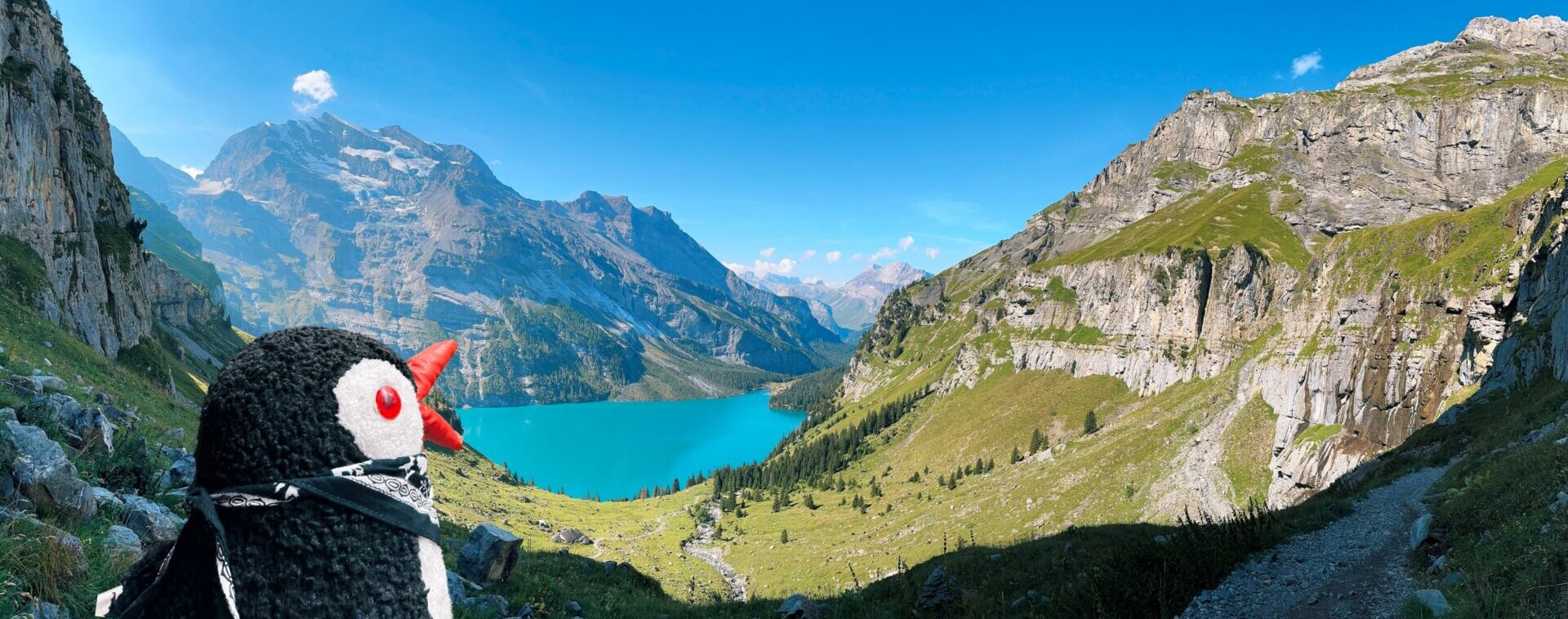
Großsee sits at around 1,640 meters above sea level and is one of the first lakes you reach from the Tauplitzalm parking lot. It’s smaller compared to some of the others on the plateau, about 350 meters long and 150 meters wide, but its calm, glassy surface and easy access make it a favorite early stop. The lake reaches a depth of around 11 meters and remains cold even in summer, thanks to its sources of snowmelt and underground springs.


We say our goodbyes, figuring we’ll loop around the lakes, enjoy the views, and then catch the chairlift back down later in the day. That was the plan, at least. A solid one, casual, scenic, not too ambitious. But hikes have a way of rewriting themselves. We start making our way toward Tauplitzsee, the next lake on the route, with the trail gently climbing and curving through meadows. Not far beyond, the Grazer Hütte comes into view, sitting in a postcard-perfect spot with peaks behind it and cows wandering nearby. Spirits are high, the weather’s perfect, and we’re still thinking we’ll be back at the top station by late afternoon. But the trail and the day have other plans.


Our first real stop is the Steirersee Viewpoint, and honestly, it’s the kind of place that makes you forget you’re supposed to keep moving. At around 1,895 meters above sea level, it opens up to a wide, breathtaking view over the deep blue Steirersee far below, tucked between steep rock walls and alpine slopes. There are plenty of benches here, perfectly placed for kicking back, catching your breath, and just soaking it all in. From this spot, you can see the towering peaks of the Totes Gebirge stretching across the horizon, with the Dachstein massif off in the distance on a clear day. It’s quiet, still, and absolutely one of those “let’s just stay here a bit longer” moments.


Descent to Steirersee: Into the Heart of Tauplitzalm
From this viewpoint, we start descending the rocky path toward Steirersee. The trail zigzags through alpine pines and opens up to clearings that feel straight out of a movie set. It doesn’t take long before the lake comes into full view, calm, cold, and stretched out like a mirror beneath the cliffs. The closer we get, the more the terrain changes. Rocky sections give way to grassy patches, and the air cools noticeably. We reach the lake’s edge, find a quiet bench just above the shore, and decide it’s the perfect spot for lunch. It’s peaceful, no one around. After eating, some of us dared to dip into the icy water. Not everyone is that brave.


Steirersee sits at about 1,447 meters above sea level and stretches roughly 800 meters in length, surrounded by steep limestone cliffs that rise dramatically from its northern shore. At its deepest point, it reaches nearly 29 meters deep enough to stay cold year-round and rarely ever warm enough for a casual swim. The lake is part of a protected nature reserve and plays a vital role in the plateau’s hydrology. In summer, it reflects the surrounding peaks like a postcard; in winter, it’s often covered in snow and ice, untouched and wild. You’ll find no boats, no commercial activity, just clear alpine water and silence.
The Legend Beneath the Water
Locals say that on quiet evenings, when the air is still and the lake glassy, you can hear faint singing from beneath the surface of Steirersee. According to legend, a shepherd once lost his way during a storm and found shelter near the lake. He claimed to hear soft, melodic voices, almost like a lullaby, coming from below. Some say it was mountain spirits, while others believe it was a drowned village that was swallowed by the lake centuries ago. No one knows, but the story lingers, passed down from hikers, farmers, and old Tauplitz families. Whether you believe it or not, there’s something about the stillness of the place that makes it easy to imagine.


Waddling Onward to Schwarzensee
From the Steirersee, we continue along the trail, legs loosening up but still taking their time. The path dips and climbs gently, weaving through patches of forest and open alpine meadows. After a while, Schwarzensee comes into view, quiet and tucked away like a secret. It’s darker, moodier than the other lakes, surrounded by dense pines and cliffs that reflect off the still water. There’s barely a ripple, and not another person in sight. Schwarzensee translates to “Black Lake,” and it earns the name from its appearance. The water here is deep and clear, but because the lake is surrounded by dense forest, cliffs, and dark rock formations, it reflects very little light, especially in the early morning or late afternoon. From certain angles, the surface looks almost black, like a mirror absorbing the sky rather than reflecting it. It’s not that the water is dark; it’s that everything around it makes it look that way.


Schwarzensee is at an elevation of approximately 1,470 meters above sea level and has depths ranging from around 15 meters, depending on the season. It’s smaller than some of the other Tauplitzalm lakes but feels more hidden and enclosed, giving it a unique atmosphere. The lake is fed by snowmelt and alpine springs, resulting in icy-cold water year-round. It’s also home to rare alpine aquatic plants and a variety of amphibians that thrive in the clear, undisturbed water.

Buy Me a Ko-fi
The Legend of Schwarzensee
And every lake has a legend here, so we found out about his one. Local legend says that long ago, a shepherd tried to build a hut too close to the lake’s edge. Each time he finished building, mysterious forces tore it down overnight. Frustrated, he ignored the warnings and rebuilt it again. On the third night, the ground shook, and the lake turned black, swallowing his hut and everything in it. Since then, locals claim that the lake harbors a restless spirit, and on some early mornings, faint knocking sounds can be heard echoing from beneath the surface.
From Schwarzensee, it becomes pretty clear: there’s no turning back to catch the chairlift like we originally planned. The trail ahead calls louder than the one behind, and with no shortcut in sight, we look at each other, shrug, and decide to justgo for it, downhill all the way to Tauplitz village. That’s a 1,100-meter descent. Good idea? Probably not. Do we do it anyway? Absolutely. The sun’s still high, our legs still working (mostly), and there’s something oddly satisfying about committing to the long way down, even if we’re more waddling than hiking at this point.


The trail down from Schwarzensee isn’t exactly gentle; it’s steep, rocky, and relentless in some sections. Switchbacks cut through dense forest, and loose gravel makes it tricky to keep steady footing. Our knees start to feel it fast, and we realize this part of the hike isn’t just a casual stroll, it’s a real descent. Definitely something better suited for experienced hikers or those accustomed to mountain terrain. After a good stretch of concentrated downhill, we finally reach a crossing where the trail meets a forest road. From there, the path flattens out and the descent becomes more manageable, a steady, gentle downhill that feels like a reward after all that leg-burning effort.
On the way to the village, we pass a small, artificially made spring lake tucked into the forest, unexpected and magical. A narrow channel guides fresh mountain water into the basin, and it’s icy cold, even in the heat of summer. A water spirit made of stone is guarding it. It’s quiet, shaded, and refreshing —a perfect place to pause and cool down, even if just to splash your face or dip your hands. The chill of that water hits deep, the kind that wakes you up in the best way


From the spring lake, we continue heading down the long forest road toward Tauplitz. The path stretches ahead, lined with tall trees that offer shade and a sense of calm after the steep descent. Somewhere along the way, we come to a crossing that leads to the nearby Tauplitz waterfall, but by then, we’re too tired to add any extra steps. Legs aching and stomachs rumbling, we decide to skip it and keep moving toward the village.
What we do love, though, is how thoughtfully the last stretch of the trail is laid out. Every so often, there’s a bench, just there, waiting. Sometimes, with a view over the valley, tucked under the trees, it is always inviting. These little pauses turn the long walk into something gentler. We stop a few times, catch our breath, sip water, and enjoy the quiet. The road may feel endless at moments, but those benches remind you to slow down and appreciate where you are.


We finally reach the village of Tauplitz. Tired, dusty, and more than ready for a cold drink. Our hike ends where it all began, but with a whole lot more distance behind us. Looking back, the route is beautiful from start to finish. The descent is challenging in parts, but it keeps things interesting, with changing views, quiet forests, and peaceful stops along the way.
One of the best parts? The alpine huts that are scattered along the plateau and the route. They offer the perfect chance to take a break, grab something refreshing, and even use the bathroom, something you start to appreciate mid-hike. The only truly unpleasant part is the steep downhill stretch after Schwarzensee, which is tough on the knees and not ideal if you’re not used to mountain trails.
That said, we’d recommend this hike to anyone looking for a mix of scenery, solitude, and a bit of a physical challenge.
We also tested out our new alpine trekking poles for the first time, and honestly, on the way down, they were a total game changer. No regrets, just sore legs and a day well spent.
Pack your bags and explore Tauplitzalm!
Save This Pin for Later!

This post contains affiliate links. If you click and buy, I might earn a tiny commission, enough to help a penguin keep up its globe-trotting lifestyle. No extra cost to you, just more fish for me. Thank you for supporting the adventure!